
PhD and Postdoc projects
High-resolution wetland mapping at scale using satellite imagery and machine learning
Gyula Mate Kovács, Postdoctoral Researcher, Global Wetland Center, University of Copenhagen
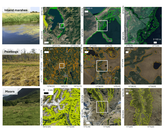
Wetlands are declining globally, but many existing maps are too coarse or inconsistent to guide action. To meet climate and biodiversity goals, decision-makers need timely, accurate information on where different wetland types are, their condition, and how they change.
My work applies satellite Earth Observation and state-of-the-art machine learning to produce high-resolution (3–10 m) wetland maps across large regions. These maps provide the basis for estimating carbon storage, refining the greenhouse-gas budgets with quantified uncertainty and aim to support conservation and restoration. Ongoing development leverages modern computer vision to scale into data-poor regions and update legacy inventories globally.
Modelling the effects of rewetting on peatland greenhouse gas dynamics
Frederikke Krogh Corydon, PhD student at the Global Wetland Center
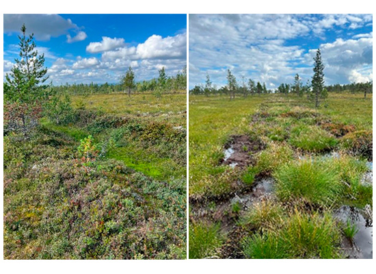
A large proportion of peatlands in mid and high latitudes have been drained for agricultural or forestry purposes, converting them from a sink to a source of CO2 to the atmosphere. Therefore, the practice of rewetting drained peatlands is gaining increasing scientific and political attention as a climate mitigation strategy. The challenge, however, is that we lack long-term observational data from rewetted peatlands, making it difficult to properly assess the timescale at which we can expect a rewetted peatland to become climate neutral. This is further complicated by the fact that different greenhouse gases (GHGs) respond differently to wet and dry conditions.
This project addresses this question through the development of a process-based model simulating the effects of rewetting on peatland GHG dynamics on decadal to centennial timescales. For this model we use data from rewetted peatlands at different stages post-rewetting to understand how the climate forcing of a rewetted peatland changes over time.
Greenhouse gas emissions and biogeochemistry of cultivated wetlands
Hans Frederik Engvej Hansen, PhD student at the Global Wetland Center
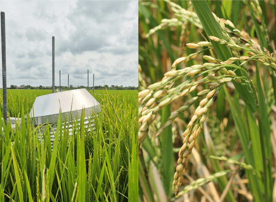
Rice is one of the most important crops and the staple food for over half of the world’s population. However, rice paddies are important sources of greenhouse gases, especially methane (CH4) of which up to 14% of anthropogenic emissions comes from rice paddies. As rice paddies often are heavily fertilized they are also potential hotspots for N2O, which is a greenhouse gas many times more potent than CO2. Many rice producing countries wish to reduce their greenhouse gas footprint and new forms of rice production practices are therefore emerging.
Although the greenhouse gas dynamics of rice paddies have been studied for many years, there remains a lack of long-term, high-frequency observations. This limitation hinders the development of accurate models and effective mitigation strategies.
This project aims to advance understanding of the biogeochemistry and greenhouse gas dynamics of rice paddies through the application of state-of-the-art measurement technologies and flux calculations.
Upscaling CO2 fluxes from tropical peatlands with remote sensing: A Knowledge-Guided Machine Learning approach
Laura van der Poel, PhD student at the Global Wetland Center
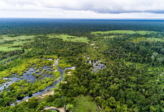
Tropical peatlands store large amounts of carbon and play an important role in the global carbon cycle, but they are increasingly under pressure from both climatic and human disturbances. Drainage and land conversion accelerate aerobic decomposition and increase the risk of widespread fires, causing tropical peatlands to shift from carbon sinks to significant carbon sources. At large scales, emissions from tropical peatlands are typically estimated using emission factors: average emissions per land use type, multiplied by its area. However, this approach overlooks important factors such as inter-annual climate variability, site history, and spatial heterogeneity, potentially leading to inaccurate estimates. Better understanding of underlying processes and drivers is needed to accurately account for tropical peatland emissions in regional and global carbon budgets.
This project aims to contribute to this task by modelling and upscaling CO₂ fluxes with greater complexity. Enabled by satellite data, we incorporate both temporal dynamics and site-specific disturbance conditions, combining machine learning (ML) with ecological knowledge. Using this knowledge-guided ML framework, we aim to capture CO₂ dynamics in tropical peatlands of Southeast Asia, with the ambition to scale the approach across the pantropical region.
Inundation and Vegetation Mapping in Tropical Wetlands
Paul Senty, PhD student at the Global Wetland Center
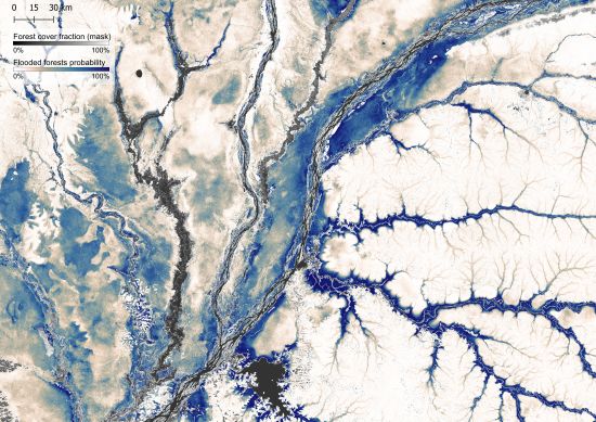
Every year, vast areas of forest and grassland in the tropics are flooded for months, creating wetland ecosystems that are vital for wildlife, local communities, and the global climate as they are important sources of methane. Yet we still know surprisingly little about how the extent and duration of these floods, as dense vegetation often hides the water from optical satellite sensors.
This project uses advanced space-borne radar technologies, which can detect water beneath vegetation, to map and monitor tropical wetlands through time.
Integrating Hydrological Modelling and Machine Learning with Earth Observation for Tropical Wetland Carbon Fluxes
Sarah Elizabeth Franze, PhD student at the Global Wetland Center
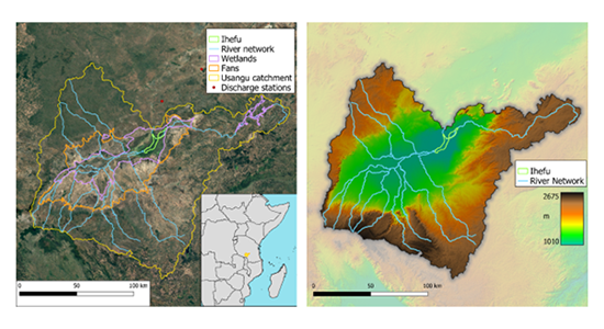
In the global methane budget, the highest emissions from natural sources are attributed to wetlands. Despite this, models of global wetland emissions remain highly uncertain, particularly in the tropics where methane fluxes are greatest. This uncertainty is in part due to the difficulty of wetland mapping due to vegetation cover and the absence of in situ flux measurements. One way to overcome this lack of information is to approach carbon fluxes from the perspective of hydrology. We know that greenhouse gas emissions are strongly linked with water table depth, which we can simulate with hydrological models and observe with satellites. In addition, we can utilize machine learning to increase the flexibility of the hydrologic model and leverage the large amount of data we get from remote sensing.
This research will merge process-based hydrologic models with data-driven surrogate models to improve regional estimates of carbon flux in tropical wetlands. An integrated hydrologic model of the Usangu Wetlands in Tanzania will be calibrated with satellite remote sensing data and serve as the base model for data-driven model development. Surrogate modeling will take advantage of high coverage earth observation datasets to uncover spatial and temporal patterns in hydrology and carbon flux, with the aim of reducing compute time and increasing model flexibility.